Professional Observation
Basic Information
Observation Details
Observation Date:
January 5, 2021Submitted:
January 6, 2021Observer:
WAC - Caleb MerrillZone or Region:
Northern WallowasLocation:
Wing Ridge NE and SW aspectsSigns of Unstable Snow
Recent Avalanches?
YesCracking?
IsolatedCollapsing?
IsolatedSnow Stability
Stability Rating:
FairConfidence in Rating:
ModerateStability Trend:
WorseningBottom Line
Ongoing winds out of the south and west yesterday were building shallow and reactive windslabs along leeward ridgelines as well as midslope terrain features. We also noticed windslabs that formed during the night of 1/4/21 were buried by a couple inches of new snow. A generally weak snowpack structure still exists on all aspects and elevations where we looked. In places where the snowpack is a bit deeper, it seemed to be harder to impact our persistent weak layers (Solstice Rain Crust and Old November Facets). However, if a smaller avalanche (say a windslab or storm slab)were triggered, it is quite possible it could step down into these weaker layers producing a potentially devastating avalanche.
Media


Advanced Information
Weather Summary
Cloud Cover:
Mostly CloudyTemperature:
22Wind:
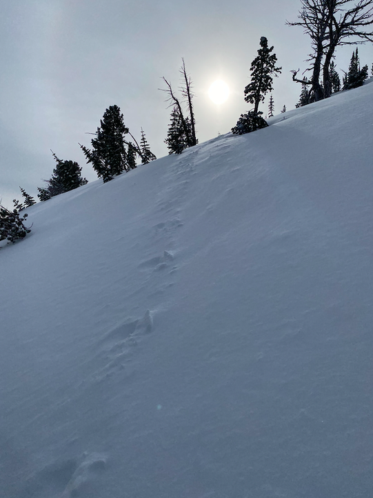
Moderate , SAnywhere from 8-12" of new snow were observed in protected areas. The storm on the night of 1/4/21 laid in wind slabs up to 6" deep in upper elevation terrain before finishing in a calmer manner. Moderate South and West winds were blowing much of the new snow around in exposed terrain. The fresh morning skin track that I followed up Phat Ridge was filled in in what I would guess was a couple of hours. See photo. Ongoing wind loading was creating shallow wind slabs at ridgelines.
Avalanche Observations
| # | Date | Location | Size | Type | Bed Sfc | Depth | Trigger | Comments | Photo |
|---|---|---|---|---|---|---|---|---|---|
| 1 | Past 24 hours |
Dollar Ridge NE 8500 |
D3 | SS | Hard to tell many details, but seemed to probably be 200 meters wide |

|
|||
| 1 | Past 24 hours |
Ridgeline separating Middle Fork and South Fork of the Imnaha River E 8000 |
D3 | SS | Hard to tell details, but large avalanche on NE aspect |

|
Snowpack Observations
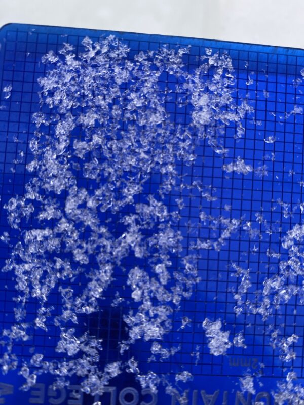
We are dealing with a complex snowpack in the Northern Wallowas. It might be a bit before we are out of the woods on this one.... Average height of snow around 8,000 feet in the wing ridge area was 48"/120 cm. There was a nice layer of 2 inches of light density snow that fell straight down from the sky at the end of the storm with little wind affect. This snow was covering up a more dense, wind affected layer of snow. In many areas the new snow felt inverted or upside down as your ski would seemingly be supported by this stiffer wind slab, only to break through to lighter density snow below. When digging deeper in the snowpack, on both a NW and SW aspect, a 1F hard slab was present above the Solstice Rain Crust and associated crust jarble. The SRC found to be a little over 2 feet deep (70cm). Below the crust, very weak faceted snow (F-4F hard) existed. We found consistent snowpack test results showing clean easy shears in both the new snow, and in the deeper persistent weak layers. See Photos below and recent video. Although we did not get propagation on the ECT, I certainly wouldn't use that data for decision making to step into more aggressive terrain. Perhaps it indicates that the 1F hard slab is making it harder to impact the SRC and associated weak snow. I always use snowpack tests as data points, not as decision making tools (unless it's helping me decide to turn around!!).


Avalanche Problems
| Problem | Location | Distribution | Sensitivity | Size | Comments |
|---|---|---|---|---|---|
 Wind Slab
|
|
Layer Depth/Date: up to 12" from 1/4/21 |
|||
 Persistent Slab
|
|
Layer Depth/Date: up to 3 feet deep, below SRC into old november facets |
Given the structure of the snowpack in this area, there is definitely potential for a smaller avalanche such as a windslab to produce enough weight to "step down" into the older snow and create a much deeper, more destructive avalanche.
Terrain Use
We did not step out onto any terrain that was steeper than 35 degrees. We utilized subridges and high terrain to manage our uncertainty within the snowpack. We avoided steep leeward and windloaded terrain. If we got pushed into smaller terrain features (convex rollovers), we slowed down our travel and managed them one at a time with eyes on.
Close